the Creative Commons Attribution 4.0 License.
the Creative Commons Attribution 4.0 License.
 | 01 Aug 2019
Time changes of dose equivalent rate above the soil surface as indication of natural attenuation processes
Alexei V. Konoplev
Toshihiro Yoshihara
Yoshifumi Wakiyama
Eight sites in the Fukushima contaminated area were surveyed for long-term changes in D-shuttle dose equivalent rate above the soil surface during 2015–2017. D-shuttle readings in most cases decreased faster than if due to radioactive decay only. More rapid decrease can be explained by natural attenuation processes, such as erosion of the topsoil, the vertical migration of radionuclides in the soil and the deposition of cleaner sediments transported by surface runoff. According to the time dependencies of D-shuttle dose rate readings integral rate constants of the natural attenuation were estimated using the exponential trend-line. Estimated rate constants of natural attenuation ranged from to 0.48 yr−1, while the correspondent a half-dose rate decrease was 1.4–95 years.


Today, 8 years after the accident at the Fukushima nuclear power plant, when emergency and short-term measures have been completed, the long-term dynamics of environmental radioactivity is becoming increasingly important. Currently, γ-radiation in areas contaminated in Fukushima is determined by two radioactive Cs isotopes – 137Cs and 134Cs released as a result of the accident (Malins et al., 2016; Konoplev et al., 2018; Okumura et al., 2016).
These radionuclides show similar behaviour in the environment since their physical and chemical properties, as well as speciation in depositions are the same.
The post-Chernobyl experience has shown that remediation of radioactively contaminated lands should be aimed at low cost, low intensity “passive” or low maintenance solutions rather than intrusive, and usually expensive, engineering techniques (IAEA, 2006a; Beresford et al., 2016). Monitored natural attenuation is one of such “passive” remediation options relying on natural processes that reduce the flux of radionuclides towards any given receptor (IAEA, 2006b; Konoplev et al., 2018). In this regard, processes of natural attenuation do not reduce the total amount of radionuclides in the environment. Rather they affect the distribution of radionuclides in space and time. Hydro-physical processes involved in natural attenuation (advection, diffusion, dispersion) may dilute radionuclides in the environment or redistribute them within the landscape (erosion and deposition), which, in turn, may lead to a gradual decrease of ambient dose equivalent rates (Malins et al., 2016; Konoplev et al., 2018).
A personal electronic cumulative dosimeter (D-shuttle; Chiyoda Technol. Corp., Japan) became available soon after the Fukushima accident in 2011. The D-shuttle dosimeter is able to measure γ-radiation with good accuracy at very fine resolution in the form of a dose equivalent rate (>0.01 µSv h−1) and storing data for more than 12 months (Čemusová et al., 2017).
Although the D-shuttle was developed to measure personal equivalent doses, most recently it was reported about the possibility of using the D-shuttle for measurement of environmental radiation (Konoplev et al., 2018; Kurita et al., 2018).
The purpose of this work is to study the dynamics of an ambient dose equivalent rates on the soil surface using D-shuttle dosimeters with a collimated lead shield and an estimate of the rates of natural attenuation due to the vertical and lateral migration of radiocesium.
2.1 Study area
The locations of the study area and observation sites, which were described in detail in previous works (Konoplev et al., 2016, 2018), and map of air dose rate at 1 m height based on the results of the seventh airborne monitoring survey, 28 September 2013 (Secretariat of Nuclear Regulation Authority, 2013), are shown on Fig. 1.
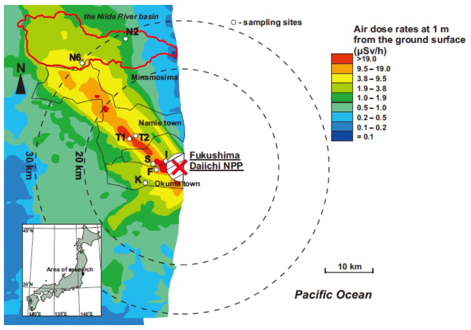
Figure 1The map of the study area with locations of observation sites and air dose rates pattern at a distance 1 m from the surface which were determined based on the results of the seventh airborne monitoring survey, 28 September 2013 (Secretariat of Nuclear Regulation Authority, 2013). Red line delineates Niida River catchment. N2 and N6 are observation sites on the Niida River catchment; T1 and T2 are observation site on Takase River catchment; I is the site on the catchment of Inkyozaka pond; S is the site on the catchment of Suzuuchi pond; F is the site on the catchment of Funasawa pond; K is the site on the catchment of Kashiramori pond.
The area contaminated after the accident at the Fukushima Dai-ichi Nuclear Power Plant (FDNPP) is characterized by a monsoon climate with annual precipitation ranging from 1100 to 1800 mm yr−1 during 2011–2016 according to the results of observations on five meteorological stations of the Japan Meteorological Agency – Haramachi, Iitate, Namie, Tsushima and Tomioka, which are located in the contaminated areas. The maximum precipitation falls on the typhoon season (mid-August–October) and the rainy season (end of May–mid-July). Temperatures are typical for a monsoon climate with a mild winter (the average monthly values of air temperatures are above zero) and with hot, rainy summer. There are no periods with soil freezing, and in conjunction with the large amounts of precipitation in summer and relatively high average annual air temperature, such conditions seem to contribute to the vertical migration of radiocesium in the soils (Konoplev et al., 2016).
It may be worth noting that the diversity of soil types in the Fukushima-contaminated areas is associated with a combination of rocks of different lithological composition, intense weathering and denudation due to high seismicity, as well as the steep slopes of mountain. Brown soils (under beech forest), ashy-volcanic, rich in humus, acidic allophonic (andosol) and leached brown soils are typical for the interfluve area. The valley bottoms are mainly used as paddy fields. Alluvial soils greatly modified due to years of land use are located here. Undisturbed alluvial soils are found in the levelled sections of the bottom of the river valley and along the canalized sections of the river beds, which is typical of intermountain depressions. Arable land, mainly rice fields, occupy about 12 % of the study area. They are mainly located in the vast depression and foothill lowlands.
2.2 Ambient dose equivalent rate measurements
Air dose equivalent rates at a height of 1 m were determined at all sites using an ALOKA pocket survey meter PDR-111. D-shuttle dosimeters with a collimated lead shield were used to measure and record hourly ambient gamma dose equivalent rates above soil surface at all selected sites. D-shuttle dosimeter has a size of 68 mm × 32 mm × 14 mm and weight of 23 g. These dosimeters employ semi-conductor technology using a Si-PIN diode (size of 12 mm × 14 mm) as the gamma-detector and are encased in a lead collimated shield (3 cm thick on the top, 3 cm thick sidewall and 2 cm thick underside) with a 3 cm × 3 cm collimation window in the underside shield opposite the diode. The devices were recording hourly dose equivalent rate inside the collimator corresponding to surface dose rate from a spot on the soil surface (with a diameter approximately equal to the installed device height) directly below the collimation window (Konoplev et al., 2018). D-shuttle dosimeters can operate up to one year without changing a battery. The dosimeters were installed at the heights of 10 to 60 cm above the soil surface using specially designed holders. D-shuttle dosimeters were installed on the sites under study from October 2015 to October 2017. Table 1 presents information about the observational sites and air dose equivalent rates at 1 m height on the sites under study at the time of installation of D-shuttle dosimeters. It should be noted that D-shuttle dose equivalent rate readings are essentially lower as compared with the air dose rate at 1 m height determined using ALOKA pocket survey meter PDR-111. However, D-shuttle readings are much more sensitive to changes in radiocesium inventory and its vertical distribution on a local spot on the soil surface covered by D-shuttle dosimeter with the collimated shield.
Table 1Description of survey sites. The date format is month/year.
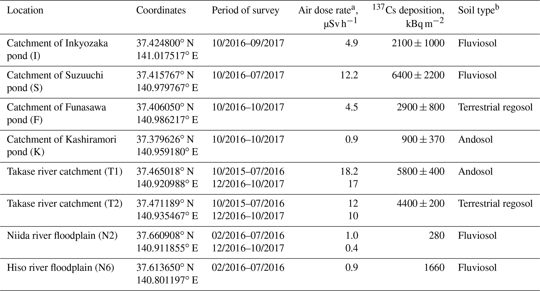
a Air dose rate on the date of the D-shuttle dosimeter installation; b according to soil classification of Japan (Obara et al., 2011).
The observed gamma dose equivalent rate can be attributed to 134Cs and 137Cs exclusively over the survey period 2015–2017. The initial ratio of isotopes 134Cs∕137Cs in fallout immediately after the accident was equal 1 (Hirose, 2012). The temporary change in dose equivalent rate due to radioactive decay of Cs isotopes can be approximated by the equation below (Yoschenko et al., 2016; Konoplev et al., 2018):
where t – current time after the accident; t0 – time after the accident for the date of D-shuttle dosimeter installation; DR(t) – current dose rate, DR(t0) – dose rate for the date of dosimeter installation; λ137 and λ134 – rate constants of radioactive decay for 137Cs and 134Cs, respectively; α134∕137 – ratio of 134Cs and 137Cs gamma kerma equal 2.687 (Saito and Petoussi-Henss, 2014).
Figures 2 and 3 illustrate the dynamics of D-shuttle readings from soil surface at several sites under study together with data on precipitation and air temperature at the nearest meteorological station of the Japan Meteorological Agency (Namie, Tomioka or Haramachi depending on the site location). The dose rate in all cases, with the exception of in the floodplain of one of the Niida River (N2) in 2016 (Fig. 4), was decreased faster than if it was only due to radioactive decay.
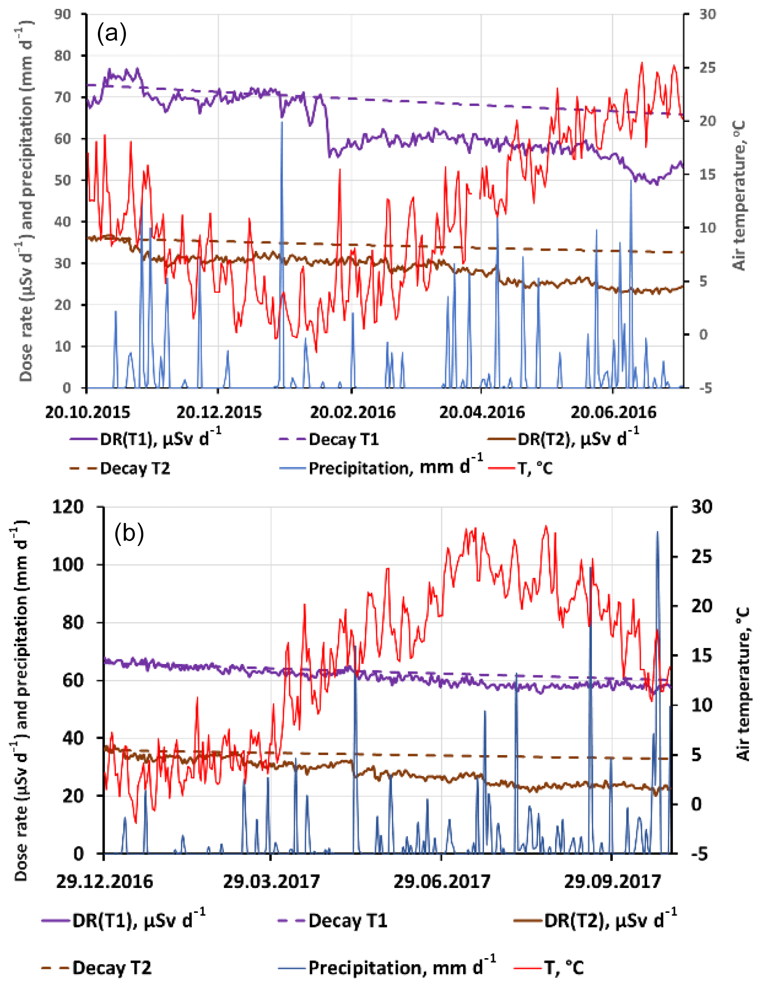
Figure 2The time dependence of the D-shuttle readings (µSv d−1) recorded with collimated shield from spot on the soil surface 10 cm below the dosimeter for the two sites T1 and T2 located in the Takase river catchment for two observation periods: October 2015 to July 2016 (a) and December 2016 to October 2017 (b) and data of daily precipitation (mm d−1) and daily average air temperature (∘C) recorded by Namie meteorological station of Japan Meteorological Agency for the similar time windows.
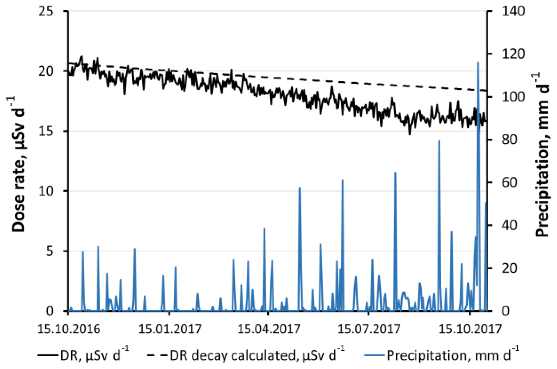
Figure 3The time dependence of the D-shuttle readings (µSv d−1) recorded from soil surface spot 10 cm below the dosimeter for the site located in the catchment area of Funasawa pond (F), Okuma town and data on daily precipitation (mm d−1) recorded by Tomioka meteorological station of Japan Meteorological Agency for the similar time window.
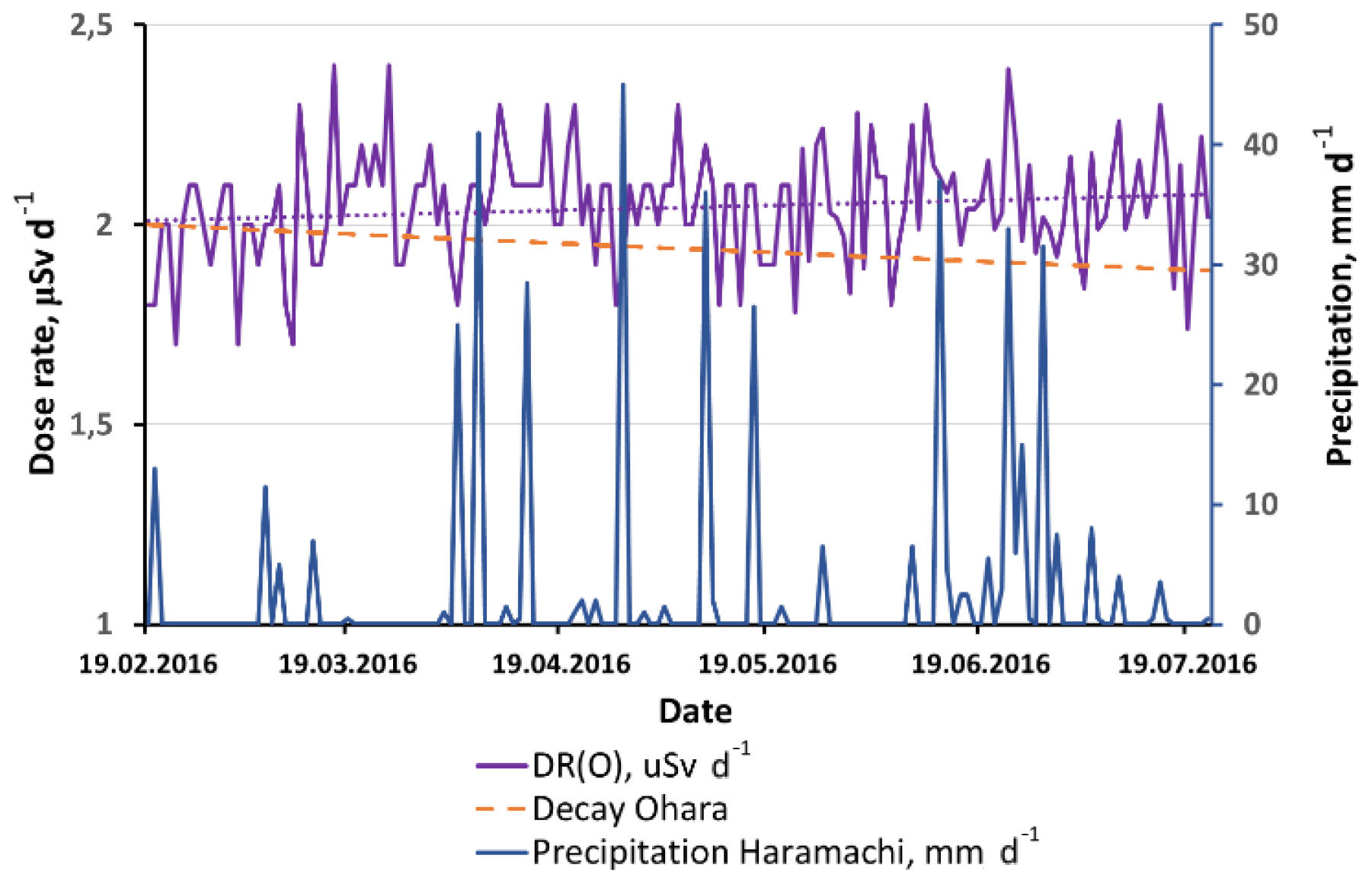
Figure 4The time dependence of the D-shuttle readings (µSv d−1) recorded from spot on the soil surface 20 cm below the dosimeter for the site, located on the floodplain of Niida river (N2) and data on daily precipitation (mm d−1) for Haramachi meteorological station of Japan Meteorological Agency for the similar time window.
A more rapid decrease in dose rate in the D-shuttle readings can be explained by natural attenuation processes, such as sheet and rill erosion, vertical migration of radionuclides in the soil profile and deposition of cleaner sediments transported by surface runoff (IAEA, 2006b).
In addition to the time dependence of the D-shuttle readings, Figs. 2 and 3 demonstrate a hypothetical decrease in the correspondent dose equivalent rate over time solely due to the radioactive decay of 137Cs and 134Cs, which are not subject to any kind of migration.
In this case, the changes in dose equivalent rate are described by Eq. (1). From the time dependence in D-shuttle readings the integral rate constant of natural attenuation processes was estimated using an exponential trend line.
The calculated natural attenuation rate constants and its half-times are presented in Table 2. The estimated rate constants of natural attenuation processes ranged from yr−1 on the catchment of the Suzuuchi pond in Okuma town to 0.48 yr−1 in the Takase River catchment with the correspondent half-reduction times being 1.4–95 years. The data shown in Fig. 2 for the catchment areas of the Takase River (sites T1 and T2) indicate a significant decrease in the dose equivalent rate during periods of flooding in November 2015 and from the end of May–June 2016. Also, a significant and sharp reduction in site T1 occurred during snowmelt and as a result of surface runoff in February 2016, when there was a sharp increase in air temperature. For the second period from December 2016 to October 2017 the natural attenuation processes at site T1 were slower, however they were faster at site T2. These variations seem to be explained by the fact that attenuation processes are strongly depend on hydrological characteristics and site-specific features of surface runoff.
Table 2Characteristics of γ dose equivalent rate attenuation for the sites under study. The date format is month/year.
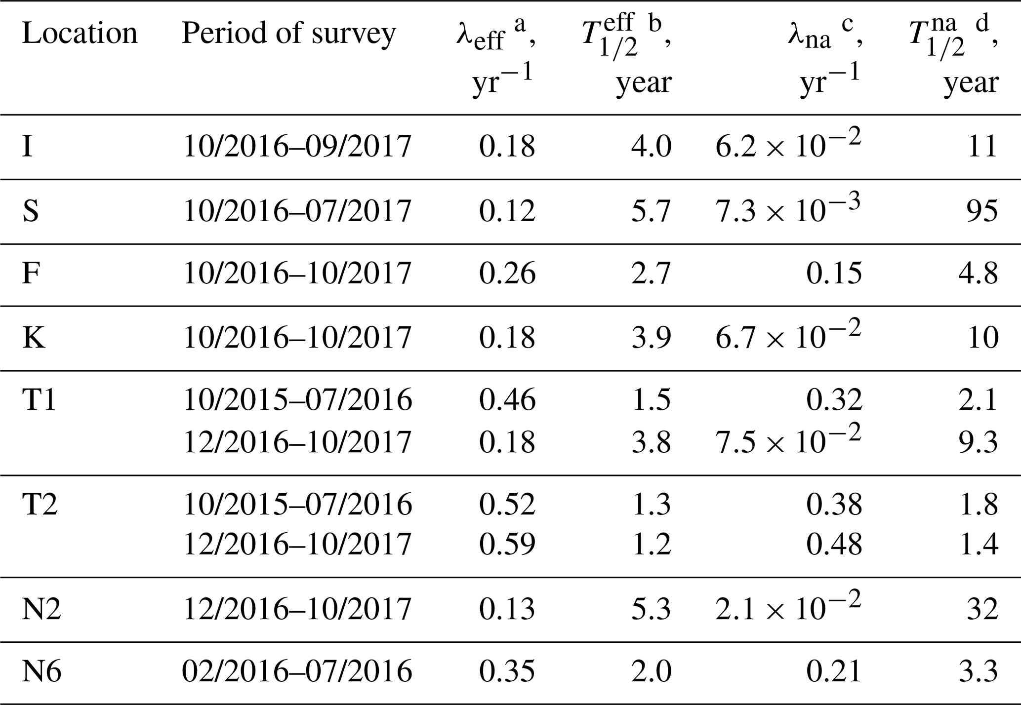
a Effective rate constant of D-shuttle readings reduction;
b half-life of effective
reduction in D-shuttle readings;
c rate constant of natural attenuation processes;
d half-life of natural attenuation processes.
There is only one site in floodplain of the Niida River (N2), where an increase in D-shuttle readings was observed due to the deposition of contaminated sediments carried by the river from the upstream during the floods in the 2016 rainy season (Fig. 4).
D-shuttle dosimeters can be used to monitor long-term change in ambient gamma dose equivalent rates above the soil surface.
During the monitoring of eight sites in the Fukushima contaminated area the readings of the D-shuttle in most cases decreased faster than in the case of radioactive decay only. A more rapid reduction in dose equivalent rate is associated with natural attenuation processes such as sheet and rill erosion, vertical migration of radionuclides in the soil and deposition of cleaner sediments transported by surface runoff.
According to the time dependences in the D-shuttle readings, the integral rate constants of the natural attenuation were estimated using an exponential trend line. The estimated rate constants of natural attenuation ranged from yr−1 on a pond catchment in Okuma town to 0.48 yr−1 in the Takase River catchment with the correspondent periods of dose rate half-reduction being 1.4–95 years. The data for the sites in the Takase River catchment indicate that a major reduction in dose rate was observed during flooding periods in November 2015 and from the end of May–June 2016, as well as during period of snowmelt. There is only one site on floodplain of the Niida River (N2) where an increase in D-shuttle dose rate readings were observed due to deposition of contaminated sediments carried by the river from upstream during the flood in the 2016 rainy season. Summing up, application of the D-shuttle for monitoring allows us to differentiate two distinct trends in the ambient dose equivalent rate, depending on specific lithological features of the monitoring spots, erosion and deposition of clean/contaminated sediments.
The data can be accessed by request to authors.
AVK and TY designed the survey. AVK and YW carried out observations. AVK provided data analysis and prepared manuscript with contribution from all co-authors.
The authors declare that they have no conflict of interest.
This article is part of the special issue “Land use and climate change impacts on erosion and sediment transport”. It is a result of the ICCE Symposium 2018 – Climate Change Impacts on Sediment Dynamics: Measurement, Modelling and Management, Moscow, Russia, 27–31 August 2018.
This research has been supported in part by a Grant-in-aid for Scientific Research from the Japan Society for the Promotion of Science (JSPS Projects 15H04621 and 18H03389).
Beresford, N., Fesenko, S., Konoplev, A., Skuterud, L., Smith, J. T., and Voigt, G.: Thirty years after the Chernobyl accident: what lessons have we learnt?, J. Environ. Radioactiv., 157, 77–89, https://doi.org/10.1016/j.jenvrad.2016.02.003, 2016.
Čemusová, Z., Ekendahl, D., and Judas, L.: Testing of the D-Shuttle personal dosimeter, Radiat. Meas., 106, 214–217, https://doi.org/10.1016/j.radmeas.2017.03.011, 2017.
Hirose, K.: 2011 Fukushima Dai-ichi nuclear power plant accident: summary of regional radioactive deposition monitoring results, J. Environ. Radioactiv., 111, 13–17, https://doi.org/10.1016/j.jenvrad.2011.09.003, 2012.
IAEA: Environmental consequences of the Chernobyl accident and their remediation: twenty years of experience. Report of the Chernobyl Forum Expert Group “Environment”, IAEA, Vienna, Austria, 166 pp., 2006a.
IAEA: Applicability of Monitored Natural Attenuation at Radioactively Contaminated Sites. Technical Reports Series No. 445, IAEA, Vienna, Austria, 105 pp., 2006b.
Konoplev, A., Golosov, V., Laptev, G., Nanba, K., Onda, Y., Takase, T., Wakiyama, Y., and Yoshimura, K.: Behaviour of accidentally released radiocesium in soil-water environment: looking at Fukushima from a Chernobyl perspective, J. Environ. Radioactiv., 151, 568–578, https://doi.org/10.1016/j.jenvrad.2015.06.019, 2016.
Konoplev, A., Golosov, V., Wakiyama, Y., Takase, T., Yoschenko, V., Yoshihara, T., Parenyuk, O., Creswell, A., Ivanov, M., and Carradine, M.: Natural attenuation of Fukushima-derived radiocesium in soils due to its vertical and lateral migration, J. Environ. Radioactiv., 186, 23–33, https://doi.org/10.1016/j.jenvrad.2017.06.019, 2018.
Kurita, K., Yamaguchi, M., Nagao, Y., Suzui, N., Yin, Y.-G., Yoshihara, T., and Kawachi, N.: Development of an Easy and Simple Method to Measure the Environmental Radioactivity in Trees with Efficient Personal Dosimeters, Radioisotopes, 67, 427–434, https://doi.org/10.3769/radioisotopes.67.427, 2018.
Malins, A., Kurikami H., Nakama, S., Saito, T., Konoplev, A., Golosov, V., Laptev, G., Nanba, K., Onda, Y., Takase, T., Wakiyama, Y., and Yoshimura, K.: Behaviour of accidentally released radiocesium in soil-water environment: looking at Fukushima from a Chernobyl perspective, J. Environ. Radioactiv., 151, 568–578, https://doi.org/10.1016/j.jenvrad.2015.06.019, 2016.
Obara, H., Ohkura, T., Takata, Y., Kohyama, K., Maejima, Y., and Hamazaki, T.: Comprehensive soil classification system of Japan first approximation, B. Natl. I. Agr. Sci. A, 29, 1–73, 2011 (in Japanese with English summary).
Okumura, M., Machida, M., and Kitamura, A.: Evaluation of ambient dose equivalent rates influenced by vertical and horizontal distribution of radioactive cesium in soil in Fukushima Prefecture, J. Environ. Radioactiv., 151, 38–49, https://doi.org/10.1016/j.jenvrad.2015.09.014, 2016.
Saito, K. and Petoussi-Henss, N.: Ambient dose equivalent conversation coefficients for radionuclides exponentially distributed in the ground, J. Nucl. Sci. Technol., 51, 1274–1287, https://doi.org/10.1080/00223131.2014.919885, 2014.
Secretariat of Nuclear Regulation Authority: Monitoring air dose rates from a series of aircraft surveys 30 months after the Fukushima Daiichi NPS accident. December 25, 2013, available at: http://radioactivity.nsr.go.jp/en/contents/9000/8700/view.html (last access: 21 June 2019), 2013.
Yoschenko, V., Nanba, K., Yoshida, S., Watanabe, Y., Takase, T., Sato, N., and Keitoku, K.: Morphological abnormalities in Japanese red pine (Pinus densiflora) at the territories contaminated as a result of the accident at Fukushima Dai-Ichi Nuclear Power Plant, J. Environ. Radioactiv., 165, 60–67, https://doi.org/10.1016/j.jenvrad.2016.09.006, 2016.