the Creative Commons Attribution 4.0 License.
the Creative Commons Attribution 4.0 License.
 | 22 Apr 2020
Two decades of GPS/GNSS and DInSAR monitoring of Cardona salt mines (NE of Spain) – natural and mining-induced mechanisms and processes
Xavier Rodriguez-Lloveras
Carolina Puig-Polo
Nieves Lantada
Jose A. Gili
Jordi Marturià
Cardona area presents surface rising and subsidence active movements. In 1999 a series of sinkholes appeared due to the infiltration of Cardener River water into the mine tunnels, damaging surface infrastructures. Since then, high precision GNSS/GPS was used annually to position a network of 40 points spread over the area. GNSS/GPS work is carried out with the Fast-Static (FS) method. Additionally the surface movements have been monitored with satellite Differential Interferometry Synthetic Aperture Radar (DInSAR). Results indicate that the movement has a complex spatial distribution although consistent along time. Some areas show surface rising during the last two decades, while other areas show subsidence. The use of the two techniques allowed to determine the most plausible causes of these movements generated by a set of interwoven natural and human-induced complex processes.


Cardona is a town located at the north-west of the province of Barcelona, on the area known as the Conca Potàssica Catalana (Potash Basin or CK), which is a great saline unit part of the evaporitic lithologies of the region known as Central Catalan Depression, part of the Ebro River Depression (NE Spain; Fig. 1).
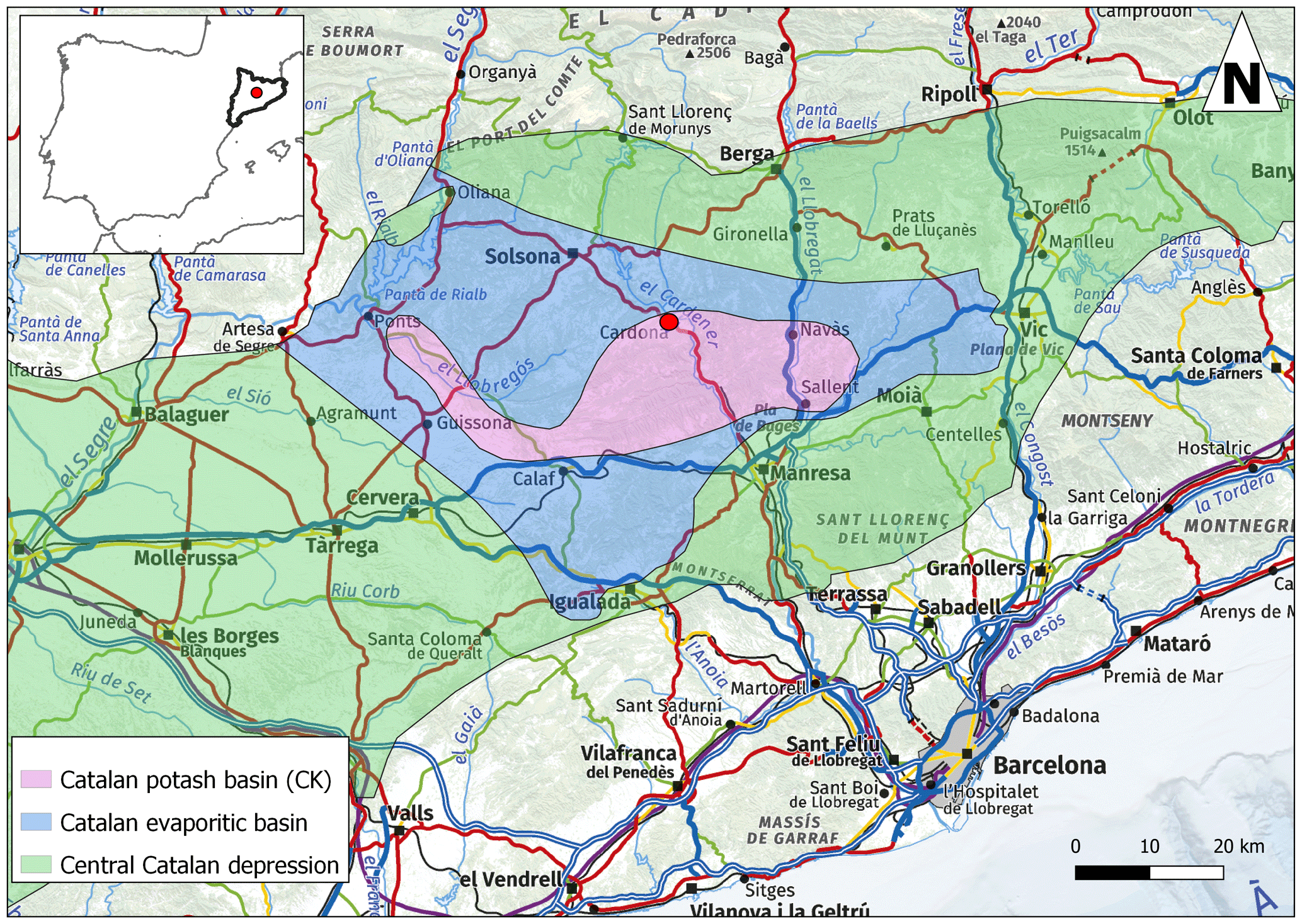
Figure 1Location Map of Cardona town on the Catalan Potash basin (CK) with is part of the evaporitic basin of the Central Catalan depression located at NE Spain.
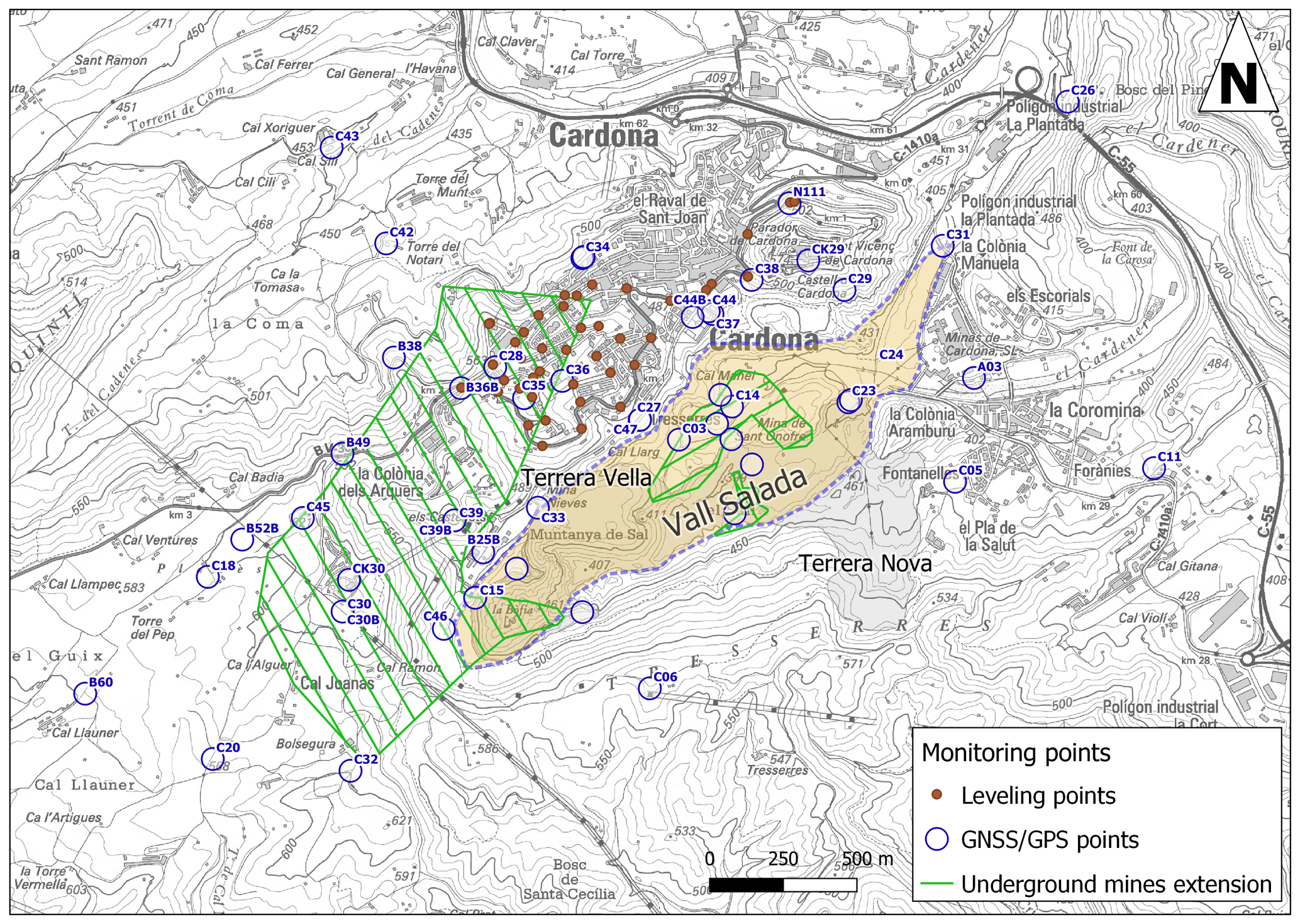
Figure 2Different locations of the Cardona area including the underground mine extension and the Situation of the GNSS/GPS and levelling points.
CK origin is a consequence of the evaporation of an inner sea 40 million years ago, during the upper Eocene. In this epoch this area was under marked subsidence being one of the deepest zones of the former sea. This condition, combined with the active tectonics of the Alpine orogeny, led to the formation of a lagoon connected with the Atlantic ocean, which dried in time due the warm and tropical climate, leading to a mass crystallization of gypsum and saline units (the latter being composed by an alternation of potash salts layers, mainly sylvinita and carnalita (Marín y Bertrán de Lis, 1923; Monzón et al., 1989). These units were progressively buried under the Sanahuja and Solsona formations (Font Soldevila, 2006), while the tensions of the orogeny and the plasticity of the evaporitic units evolved to a saline diapirism, creating the salt-cored Cardona anticline (Masana and Sans, 1995; Wagner et al., 1971). The erosion of this anticline exposed the Muntanya de Sal landmark, which is the exposed tip of the salt diapir, and generated the Vall Salada valley (Fig. 2), characterized by the outcrop of the saline formation (Font Soldevila, 2006). Due the accessibility to the saline formation, this resource has been exploited since the Neolithic, being the oldest crystalline salt exploitations in Europe (Lopez de Azcona, 1933; Weller, 2002). Although salt has been extracted there for centuries, the most intensive extraction was concentrated on the second half of the 20th century, when “Mina Nieves” underground mine was active. In this period, sodium salts were intensively used for the production of plastics, bleach, soap, glass, and so on, whereas potassium salts were used for the production of fertilizers and explosives. The underground mining caused significant changes in the topography and hydrology of the area.
As a consequence of the combination of the natural processes, such as the saline halokinesis, and human mining activity, the Cardona area presents complex surface rising and subsidence active movements. In 1999 more than 150 sinkholes appeared in the east section of the Vall Salada, damaging surface infrastructures, pipes and several mine facilities. After thorough studies, these phenomena were attributed to the infiltration of water from a phreatic conduit feed by the Cardener River into the mine galleries. In order to stop the sinkhole appearance, the river was channelized through a 250 m bypass tunnel (Lucha et al., 2008). Since then, the area has been monitored for the follow-up of the phenomena, using GNSS (Gili et al., 2009, 2011), and satellite Differential Interferometry Synthetic Aperture Radar (DInSAR) techniques (Mora et al., 2007a), complemented with levelling surveys.
This article analyses and discusses the data of the monitoring techniques gathered during two decades, focusing on its applicability and capacity to provide reliable data to determine the complex subsidence-heave processes occurring in Cardona area.
Monitoring of surface movements in Cardona has mainly been performed trough GNSS/GPS surveys and DInSAR data, complemented with levelling surveys.
The GNSS/GPS monitoring started in 1997, being repeated in a yearly basis. The current situation of the local network of Cardona is that shown in Fig. 2. Two local vertexes have been used as base points, the so-called CK29 and CK30, which belong to the CK Network covering the whole Potash Basin (Gili et al., 2010). The other 41 points are control points. As the network aims to detect general movements in the whole area (big units) and not sudden/localized movements (small sinkholes or local slides, for instance), the density of control points is relatively low (inter-point distances ranging between 200 m and 1 km).
A GNSS/GPS precision system has been used, specifically the Fast-Static Method (also called “GPS with post-processing”). The recording rate (Δt) was 15 s in the first campaigns, and 5 s since October 2010. The elevation angle threshold is 10∘ (registering the signal from the “low” satellites tends to improve the vertical precision of the final elevations, our main goal). Duration of the logging sessions are typically 30 min per control point. With this methodology, the a priori precision (σ) of the results is 1 cm in plan and 2 cm in elevation.
The DInSAR monitoring was performed using images from the ERS, ENVISAT, COSMO-SkyMed, and SENTINEL satellite missions. ERS and ENVISAT data (1992–2010) have a spatial pixel resolution of 40×40 m and a revisit time of 35 and 30 d. COSMO-SkyMed, data (2010–2015) has a spatial pixel resolution of m and an irregular revisiting time from 4 to 16 d, depending on the available satellites. Finally SENTINEL data (2015–2019) has a spatial pixel resolution of 20×20 m and a constant revisit time of 6 d, which allow a better monitoring of the processes occurring in Cardona. During the last decades, DInSAR techniques have been widely improved, developed and applied (Blanco-Sànchez et al., 2008; Ferretti et al., 2000), proving to be an excellent tool for monitoring regional land surface movements of wide areas with sub-centimetric precision. In this study, an advanced DInSAR processor, known as Persistent Scatterer Interferometry (PSI), was applied. This process discriminate the different components of the interferometric signal, obtaining the final ground motion measurement with a higher precision (Mora et al., 2007b). One of the main drawbacks of this processing technique is that it requires a low variation of the radar signal response during the analysis period in order to obtain high quality measurements (interferometry coherence). As a consequence, soil covers experimenting great variations along the year return poor coherence. This limitation is the reason why this technique allows the measurements of surface movements mainly in urban areas or isolated buildings, but is limited in areas with important surface changes in time such as vegetated areas or areas with human-induced changes, such as landfill/excavation activities. Land use change limitation is notorious on the western section of the Cardona area, reducing significantly the data available in this area. To corroborate the DInSAR-detected movements, a high-precision levelling network was implemented in Cardona urban area. The levelling works began on January 2006 and finished on October 2012 after thirteen campaigns, and were performed using an automatic electronic (digital) level, measuring elevation increments along some traverses (Fig. 2).
It should be kept in mind that each monitoring network has a different resolution, extension, advantages and limitations, showing some differences on the measured points. Therefore, it is necessary to determine the results of each technique individually and later discuss the comparison between different techniques, in order to obtain unique coherent interpretation of the monitored movements.
GNSS/GPS measurements show two areas with different behaviours along the Vall Salada lineation.
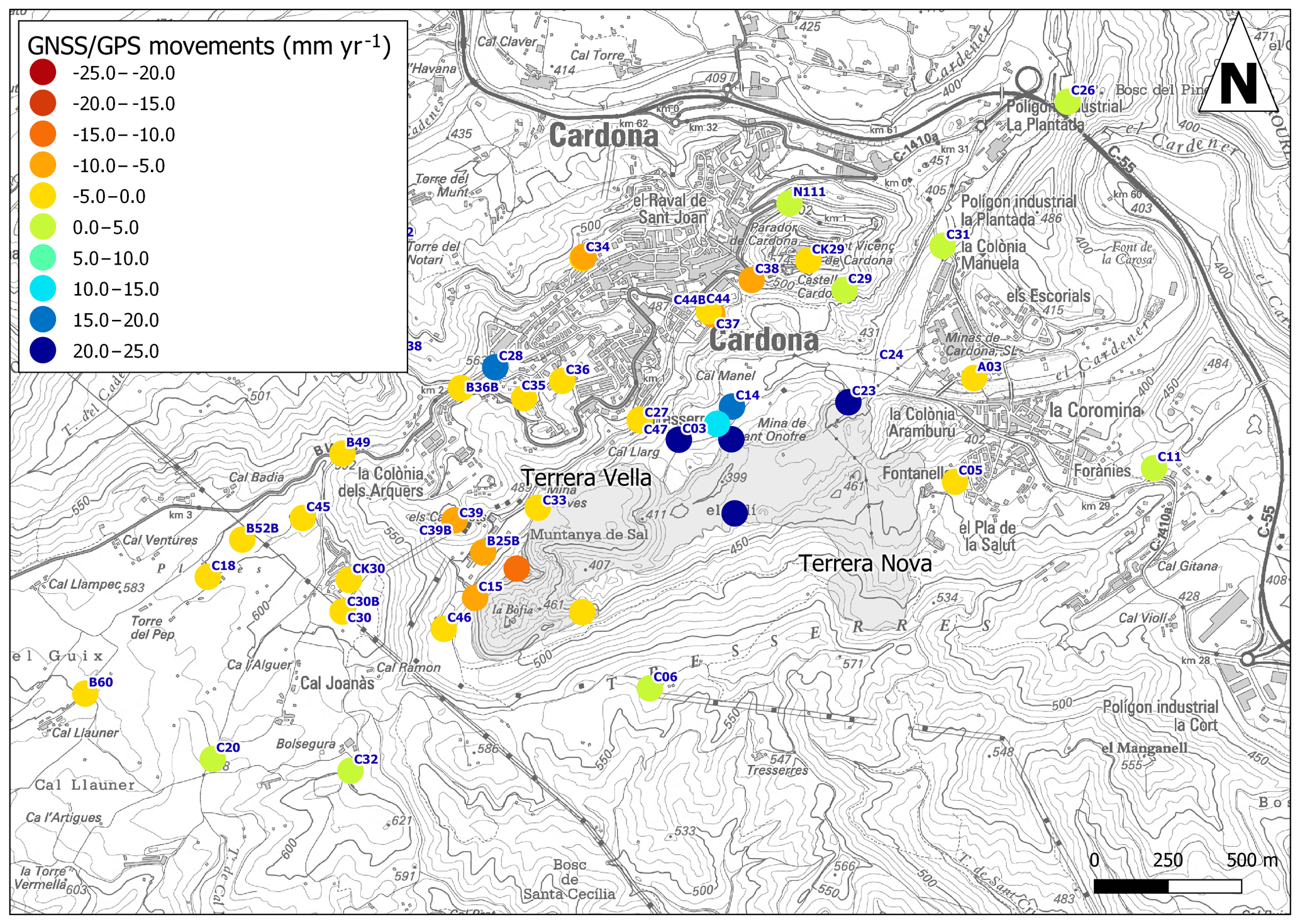
Figure 3Terrain movement velocities obtained from the 20 year movement dataset of GNSS/GPS measures.
The area to the west, next to the Muntanya de Sal, presents the greatest subsidence (negative values) of the area, with rates up to −12 mm yr−1. On the contrary, on the east section of the Vall Salada, a heave (positive) sustained velocity near to 20 mm yr−1 is detected in five points between the old (Terrera Vella) and the new (Terrera Nova) mine waste areas (Fig. 3).
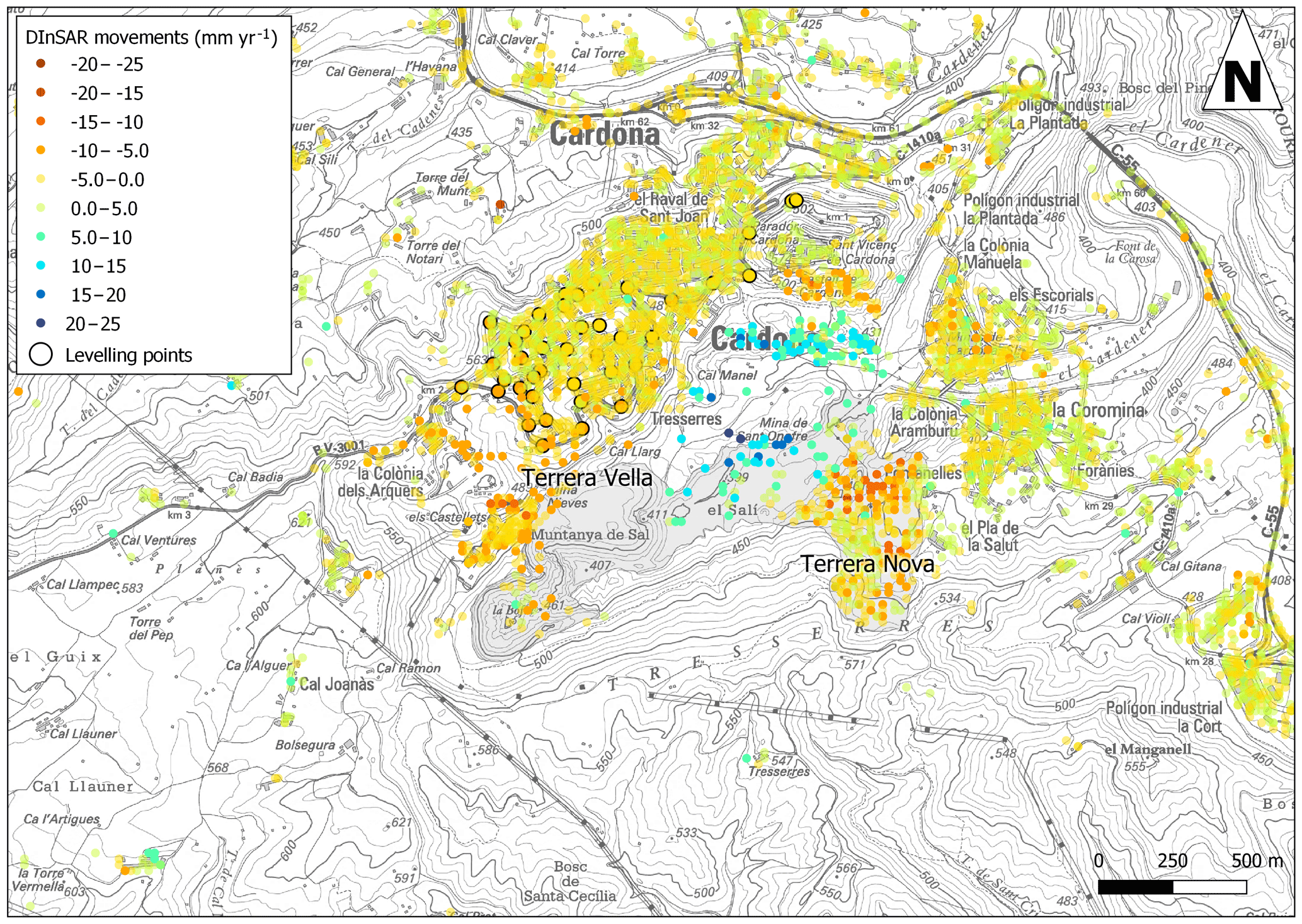
Figure 4Levelling based and DInSAR based terrain movement velocities determined from movement measures gathered in its respective datasets.
DInSAR measures also deliver a differential behaviour. Greater subsidence is detected at the south-west of the urban centre of Cardona, with values ranging between −10 and −15 mm yr−1. On the contrary, heave values between 10 and 20 mm yr−1 are measured on the north eastern section of Vall Salada (Fig. 4).
Levelling campaign measures indicate subsidence of the urban area of Cardona with values ranging from ∼0 to 7.5 mm yr−1, which are consistent with DInSAR measures in this area (Fig. 4).
GNSS/GPS and DInSAR results are consistent in the identification of two main areas with different terrain movement trend. Both techniques show a subsiding area located on the south and western areas of the Muntanya de Sal with rates between 10 and 15 mm yr−1, and a maximum heave between 10 and 20 mm yr−1 on the east section of Vall Salada. In both directions of movement the two techniques show some differences on the location of the maximum subsidence and heave points. These differences can also be detected between DInSAR and levelling data. The most plausible reason for these differences is related with the technique's resolution. GNSS/GPS and levelling techniques are point based, meaning its results are restricted to a single point of measure. On the contrary, DInSAR data represents an extension of terrain (pixel), which varies with the satellite's sensor resolution (from 40×40 to 15×15 m). Consequently, in DInSAR data higher or lower punctual displacements are masked by the general pixel movement, while GNSS/GPS and levelling control points might be in locations with higher or lower movement than its surroundings. Anyhow, results between techniques are consistent considering its resolution and precision (Gili et al., 2010; Marturià et al., 2006).
The area where GNSS/GPS and DInSAR show subsidence is located on the geological contact between the Cardona formation (salts) and the Igualada marls formation, above the old Nieves mine tunnels. This location explains the subsidence movements, as the contact presence infers ground debility and the excavated tunnels introduce a change in the ground tension's equilibrium. This change induces deformations of the surrounding ground (strain) producing a tension (stress) rearrangement to reach a new mechanical equilibrium (Zangerl et al., 2003). These changes are reflected on the surface by generating subsidence, which in absence of new processes of erosion or solution of ground materials, tend to evolve to stability as the new ground equilibrium is reached (Pipia et al., 2007).
In addition to the western areas of the Muntanya de Sal,SENTINEL data also show subsidence on the Terrera Nova area. In this location GNSS/GPS control points were not installed as this landfill deposit has been progressively removed due environmental issues. Despite this land cover change, the surface materials are similar and the DInSAR coherence has been kept. Consequently, the movements on this section detected with this technique cannot be considered as a surface movement.
Regarding the area where GNSS/GPS and DInSAR show heave, this is located between the Terrera Vella and the old Cardener river bed. In addition, DInSAR data also show a heave area on the section close to the old river bed, where no GNSS/GPS control points are installed. This area is located at the axis of the diapiric anticlinal formation showing the outcrop of the evaporitic units (salt gypsum and anhydrite). As this is an active diapiric process (Masana and Sans, 1995; Wagner et al., 1971), and the heave is stable in time, the halokinesis is considered the main cause generating heave. Anyhow, the exposure of the evaporitic lithologies together with the known issues with the water infiltrations (Lucha et al., 2008), can induce to the eventual rehydration of the gypsum and anhydrite, which can contribute to the ascending movement (Yilmaz, 2001).
The results of GNSS/GPS and DInSAR techniques indicate that the latest Earth observation missions based on DInSAR (SENTINEL), combined with advanced processing techniques, greatly improves the measure interval, spatial resolution, spatial coverage and revisiting time from previous DInSAR data, making this technology an excellent option to monitor areas with good signal response. On the other hand, data based on GNSS/GPS data deliver high quality punctual information which is extremely useful to determine local trends on any type of terrain and land cover.
In Cardona area the movements induced by natural and mining-induced processes have been monitored during the last two decades with two main techniques: GNSS/GPS and DInSAR. Results obtained with both methodologies are compatible in location trend and magnitudes, allowing detection of two main areas with inverse significant movements (subsidence and heave). Subsiding area is located at west section of Vall Salada and is considered related with the old mine tunnels and its induced strain/stress mechanical ground re-equilibrium. The upheaval movements are centred on the east section of Vall Salada and are a consequence of the active halokinesis and hydration of subsoil evaporites.
This study confirms that the latest Earth observation missions and techniques are an excellent option to monitor areas with good signal response, and its combination with other high resolution monitoring techniques such as GNSS/GPS allow to determine the interwoven causes of land movement related with multiple complex processes.
The data used in this work is proprietary of the government of Catalonia through the Institut Cartogràfic I Geologic de Catalunya (ICGC) and third-party suppliers and clients. In particular cases, some of this data can be made available by ICGC under request. Queries may be addressed to ICGC mailbox https://www.icgc.cat/en/The-ICGC/Contact/Contact-mailbox (last access: 19 February 2020).
JM supervised the different ICGC projects from which the data was obtained. JAG, NL and CPP conceived and planned the location points and frequency of the GPS/GNSS measurements, carried out the GPS/GNSS field campaigns and processed the data. XRL and JM compiled and processed the DInSAR and leveling Data and contributed to the interpretation of the results. XRL took the lead in writing the manuscript. All authors provided critical feedback and helped shape the research, analysis and manuscript, and read and agreed to the published version of the work.
The authors declare that they have no conflict of interest.
This article is part of the special issue “TISOLS: the Tenth International Symposium On Land Subsidence – living with subsidence”. It is a result of the Tenth International Symposium on Land Subsidence, Delft, the Netherlands, 17–21 May 2021.
Blanco-Sànchez, P., Mallorquí, J. J., Duque, S., and Monells, D.: The Coherent Pixels Technique (CPT): An Advanced DInSAR Technique for Nonlinear Deformation Monitoring, in: Earth Sciences and Mathematics: Volume 1, edited by: Camacho, A. G., Díaz, J. I., and Fernández, J., Birkhäuser Basel, Basel, Switzerland, 1167–1193, https://doi.org/10.1007/978-3-7643-8907-9_10, 2008.
Ferretti, A., Prati, C., and Rocca, F.: Nonlinear subsidence rate estimation using permanent scatterers in differential SAR interferometry, IEEE T. Geosci. Remote, 38, 2202–2212, 2000.
Font Soldevila, J.: Comportament de l'aigua subterrània a la vall Salada de Cardona, PhD thesis, Departament d'Enginyeria Minera i Recursos Naturals Universitat Politècnica de Catalunya, Manresa, Spain, 2006.
Gili, J. A., Lantada, N., Puig i Polo, C., and Marturià, J.: Mejoras introducidas en la red local de monitorización de movimientos de Cardona al trabajar con doble constelación GNSS, in: VIII Semana Geomática Internacional, Proceed. 8th Geomatic Week, 3–5 March 2009, Barcelona, Spain, 1–8, 2009.
Gili, J. A., Lantada, N., Concha, A., Soler, X., Puig, C. M., and Marturia, J.: Comparing several GPS post-processing strategies for a potash basin monitoring network in northeast Spain: first results, vol. 339, IAHS Publ., Qerétaro, Mexico, 2010.
Gili, J. A., Lantada, N., Concha, A., Soler, X., Puig i Polo, C., and Marturià, J.: Primeros resultados de una red GPS de monitorización de asentamientos en la cuenca potásica catalana (NE de España), in: Proceed. 9th Geomatic Week, 15–17 March 2011, Barcelona, Spain, 1–5, available at: http://upcommons.upc.edu/handle/2117/14721 (last access: 26 October 2016), 2011.
Lopez de Azcona: Industria Neolítica de Cardona, Notas Comun. Inst. Geológico Min. Esp., 5, 61–66, 1933.
Lucha, P., Cardona, F., Gutiérrez, F., and Guerrero, J.: Natural and human-induced dissolution and subsidence processes in the salt outcrop of the Cardona Diapir (NE Spain), Environ. Geol., 53, 1023–1035, https://doi.org/10.1007/s00254-007-0729-3, 2008.
Marín y Bertrán de Lis, A.: Investigaciones de la cuenca potásica de Cataluña, Bol. Inst. Geològico Min. Esp., 64, 3–78, 1923.
Marturià, J., Mora, O., Xifre, D., Martinez, P., and Roca, A.: DInSAR techniques versus high topographic leveling surveys: The subsidence phenomena in Sallent, Proc. ECONGEO, 2, 53–57, 2006.
Masana, E. and Sans, M.: Deformación neotectónica relacionada con anticlinales de núcleo salino (NE de la cuenca del Ebro, Barcelona), Geogaceta, 20, 846–849, 1995.
Monzón, P. A., Cabrera, L., Chertó, B. C., and Sáez, A.: Los sistemas lacustres del Eoceno superior y Oligoceno del sector oriental de la Cuenca del Ebro, Acta Geológica Hispánica, 24, 205–230, 1989.
Mora, O., Arbiol, R., and Palà, V.: ICC's project for DInSAR terrain subsidence monitoring of the Catalonian territory, in: 2007 IEEE International Geoscience and Remote Sensing Symposium, 23–28 July 2007, Barcelona, Spain, 4953–4956, IEEE, available at: http://ieeexplore.ieee.org/xpls/abs_all.jsp?arnumber=4423973 (last access: 26 October 2016), 2007a.
Mora, O., Arbiol, R., and Palà, V.: The experience of the cartographic Institute of Catalonia (ICC) on continuous DInSAR monitoring of large areas, in: Envisat symposium Montreux, 23–27 April 2007, Montreux, Switzerland, available at: http://earth.esa.int/workshops/envisatsymposium/proceedings/sessions/3B4/460061mo.pdf (last access: 26 October 2016), 2007b.
Pipia, L., Aguasca, A., Fabregas, X., Mallorqui, J. J., Lopez-Martinez, C., and Marturia, J.: Mining Induced Subsidence Monitoring in Urban Areas with a Ground-Based SAR, 2007 Urban Remote Sens. Jt. Event, 11–13 April 2007, Paris, France, 1–5, https://doi.org/10.1109/URS.2007.371881, 2007.
Wagner, G., Mauthe, F., and Mensink, H.: Der salzstock von Cardona in Nordostspanien, Geol. Rundsch., 60, 970–996, 1971.
Weller, O.: The earliest rock salt exploitation in Europe: a salt mountain in the Spanish Neolithic, Antiquity, 76, 317–318, https://doi.org/10.1017/S0003598X0009030X, 2002.
Yilmaz, I.: Gypsum/anhydrite: some engineering problems, B. Eng. Geol. Environ., 60, 227–230, 2001.
Zangerl, C., Eberhardt, E., and Loew, S.: Ground settlements above tunnels in fractured crystalline rock: numerical analysis of coupled hydromechanical mechanisms, Hydrogeol. J., 11, 162–173, https://doi.org/10.1007/s10040-002-0234-4, 2003.