Articles | Volume 382
https://doi.org/10.5194/piahs-382-437-2020
Pre-conference publication
 | 
22 Apr 2020
Pre-conference publication |  | 22 Apr 2020

Assessment of Subsidence Risk Associated with Brackish Groundwater Development in the Coastal Lowlands Aquifer, Houston, Texas, USA

Neil Deeds, Michael Turco, Van Kelley, Christina Petersen, and Susan Baird
Abstract

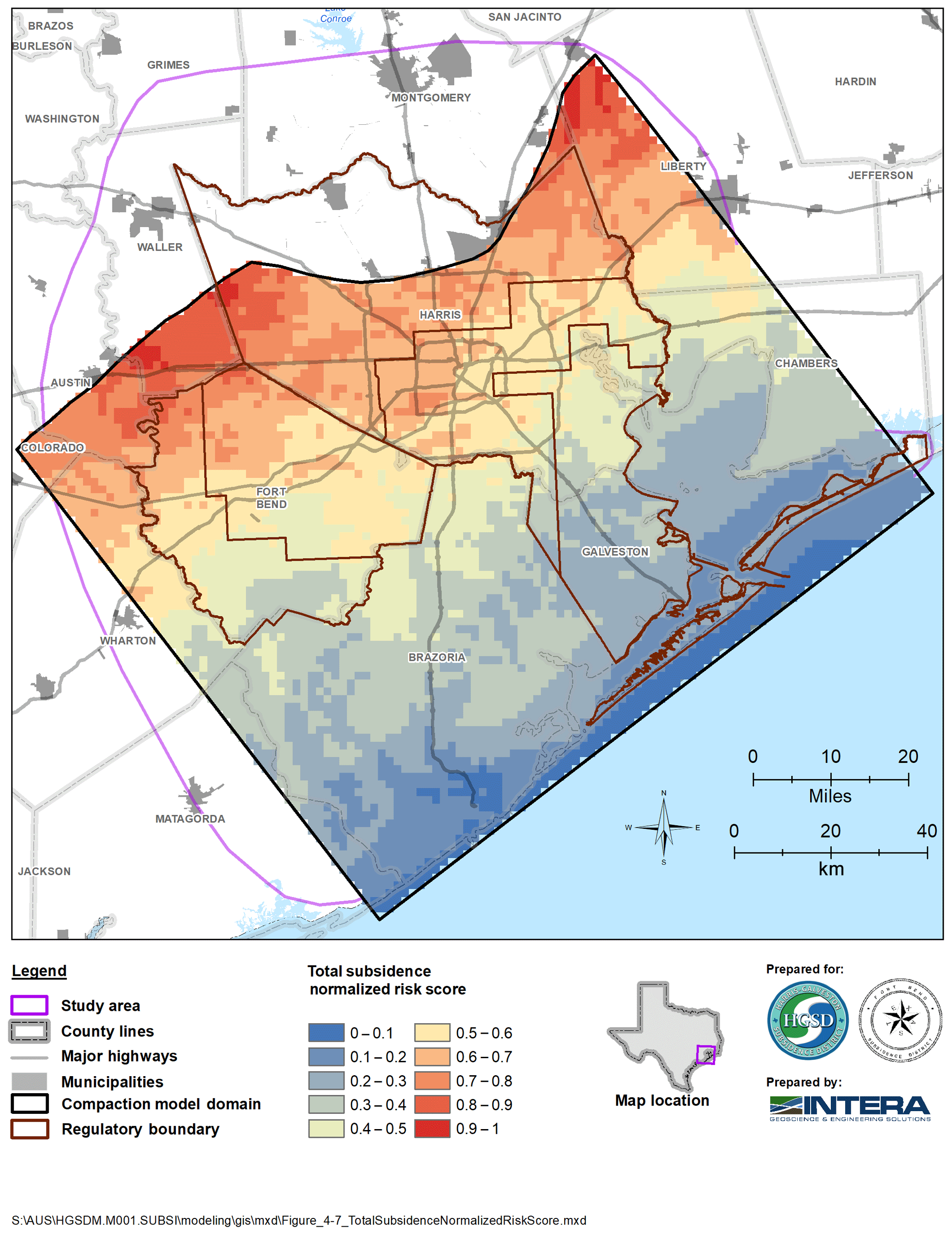
Significant undeveloped brackish groundwater resources exist within the Coastal Lowlands Aquifer System (Gulf Coast Aquifer System) near Houston, Texas, USA. As the development of these frontier resources is imminent, an improved understanding of the impact development may have on the availability of the resource and land subsidence is needed. In this region, land subsidence is caused by the depressurization of the aquifer and compaction of the many clay lenses in the subsurface. The Gulf Coast Aquifer System in the study area includes three primary water bearing units (from shallow to deep): the Chicot (Pleistocene and Pliocene) and Evangeline (Pliocene and Miocene) aquifers, and the Jasper aquifer (Miocene). Although there has been much research and data supporting the causal relation between water-level decline and subsidence in the areas of fresh groundwater development, little data exists to inform on the potential subsidence impacts upon deeper brackish groundwater development. Data were compiled, and multiple hydrologic parameters were utilized to improve the understanding of the brackish resources within the study area. Geophysical logs were compiled and analysed to refine the aquifer stratigraphy, determine the binary classification of sand and clay, and estimate the groundwater salinity. These data were used to develop a MODFLOW groundwater flow model to estimate the risk of compaction and land subsidence upon the development of brackish zones within the Jasper aquifer. Compiled data detailing the total clay thickness, clay bed thickness, and clay bed location were input into the model along with a hypothetical stress to predict compaction within the Jasper aquifer across the study area while incorporating the observed heterogeneity in clay properties. Using the results from the model simulations and two other risk performance measures (depth of burial and surface flood risk), the total subsidence normalized risk score was estimated. The results of this study confirm the potential for compaction in the Jasper aquifer and for land subsidence to occur upon development. Areas with the highest risk are located in the up-dip, inland areas, near where the aquifer becomes fresh and is currently used for municipal supply. The results will inform water managers and planners in the Houston area on the future availability of brackish groundwater resources.

1 Introduction

The Houston Region, which includes the City of Houston, TX, USA and the surrounding communities is the 3rd largest community in the United States. Due to prolonged and extensive groundwater development of the Gulf Coast Aquifer system, widespread subsidence has resulted in the regulation of groundwater use, and the conversion to alternative sources of water that will not contribute to subsidence.

Treated surface water is currently (2019) the primary alternative source water and accounts for the largest overall source as a percentage of total water demand in the Houston Region. Currently the region sources surface water from Brazos, San Jacinto, and Trinity River Basins in addition to groundwater, and wastewater reuse. Other resources and water management methodologies will be needed as population in the region continues to increase. Brackish groundwater is a potential alternative water supply that, along with other improved water development strategies, needs to be investigated to assure water planners and officials that adequate water supplies will be available for the region to support future projected increases in municipal, and industrial water needs while managing subsidence.

1.1 Hydrogeologic Investigation

The Coastal Lowlands Aquifer, locally referred to as The Gulf Coast Aquifer System, in the study area has been the primary water source for the region's municipal, industrial, and agricultural water supply. The Chicot, Evangeline, and Jasper aquifers are the three primary water bearing units of the aquifer system, with the Chicot being the shallowest and the Jasper being the deepest. Brackish and saline resources exist in each of the primary water bearing units of the Gulf Coast Aquifer System, each composed of a complex sequence of interbedded sands and clays. Extensive development of these aquifers has resulted in the compaction of the aquifer and measured land subsidence. Land subsidence can contribute to infrastructure damage, coastal inundation, and inland flooding.

https://www.proc-iahs.net/382/437/2020/piahs-382-437-2020-f01

Figure 1Compressibility as a function of depth for clay samples collected near Houston, Texas, TX, USA (from Gabrysch and Bonnet, 1974).

The distribution of major sand and clay-rich sequences within the aquifer system was determined to better understand the relation between aquifer lithology, stratigraphy, and salinity. Nine stratigraphic cross-sections were created based on 209 geophysical logs to locally define aquifer stratigraphy. A total of 294 geophysical logs were used to interpret aquifer lithology in a binary classification of sand and clay. A total of 299 geophysical logs were used to estimate groundwater salinity and determine locations where brackish resources exist within the District. Brackish resources are defined

for this study as those areas within the Gulf Coast aquifer that have total dissolved solid concentrations between about 1000 and 3000 mg L−1. The nine cross sections developed during this preliminary investigation include aquifer structure boundaries, aquifer lithology and water salinity classification (Young et al., 2018).

Compaction and resulting subsidence in the Gulf Coast aquifer in the study area is caused by the reduction of the pore pressure in the clay beds because of groundwater pumping. When water-levels decline because of groundwater withdrawal, the pressure within the aquifers decline decreasing the pore pressure within the numerous clay lenses resulting in compaction. There has been extensive research in the Houston region on the potential for compaction of the Chicot and Evangeline aquifers (Gabrysch and Bonnet, 1974, 1976a; Kasmarek, 2012). As such, this effort focuses on frontier sections of the Jasper, that have never been developed, to determine the subsidence risk associated with potential future development of these brackish resources. The vertical hydraulic conductivity of the clay lenses and the inelastic clay specific storage of the Jasper were interpreted from geophysical logs and historical research. Both properties are strongly correlated with depth of burial, with the potential for compaction decreasing with greater burial depths (Fig. 2).

https://www.proc-iahs.net/382/437/2020/piahs-382-437-2020-f02

Figure 2Simulated compaction as a function of depth after 10 years of production for the three sensitivity cases (see Table 1).

Download

2 Modeling

A numerical groundwater flow model was developed to estimate compaction in the Jasper Aquifer in the study area from a hypothetical brackish groundwater development project. The numerical model was developed using the United States Geological Survey code MODFLOW (Harbaugh et al., 2000). This model simulated subsidence with the MODFLOW SUB package (Hoffman et al., 2003) which is the same package utilized in the most recent regional MODFLOW model published in the region (Kasmarek, 2012). The model developed for this study is called the Jasper Compaction Model (JCM).

The JCM accounts for the variability in clay properties and parameters controlling compaction which are correlated to aquifer depth of burial across the study area. Clay bed location and properties were determined by the nearest analysed geophysical log. Because the analysis desires to estimate risk within the brackish Jasper Aquifer, the model must simulate compaction over a large study area. The model is composed of one-mile square cells. To make the analysis practicable, brackish projects were simulated at the central cell of regions approximately 23 km2 in area. This resulted in 117 modelled brackish projects which provided adequate coverage both spatially and with depth. Each hypothetical project was represented in the model as a head-controlled boundary assumed to have an equal drawdown of approximately 150 m. The use of a constant drawdown versus a constant rate boundary normalized the compaction results.

Table 1Summary of direction of parameter variation for Jasper Compaction Model sensitivity analysis.

Download Print Version | Download XLSX

Due to the uncertainty in the model parameters used in the JCM, a sensitivity analysis was performed to better understand the influence of model parameters on the results Three assemblages of model parameters were used grouped in a low impact, base (average), and high impact scenarios (Table 1).

Figure 2 plots compaction versus depth for the three sensitivity cases. The analysis shows that generally, for all scenarios, as depth exceeds about 1200 m, there is little change in model results as depth increases. Above about 600 m of depth, compaction rates for the base scenario are similar to typical observed rates of subsidence in the Houston region. While not the focus of this study, it is clear from a review of Fig. 2, that areas where the developed resources is within about 600 m of land surface in the Jasper aquifer (typically fresh water in the Houston Area), the risk of compaction in the aquifer materials is relatively high.

https://www.proc-iahs.net/382/437/2020/piahs-382-437-2020-f03

Figure 3Total subsidence normalized risk score in the Jasper aquifer, Gulf Coast Aquifer system, near Houston, TX, USA.

3 Jasper Brackish Resources Risk Assessment

The approach used to develop a relative risk map for subsidence from development of the brackish Jasper Aquifer is based upon Multi-Attribute Utility Theory. Utility theory is a tool widely used by decision analysts for converting their preferences, expressed in monetary terms or other relevant performance measures, into a normalized scale to facilitate comparison of options (Clemen, 1986). In this case, an option is the relative risk of subsidence from pumping the brackish Jasper Aquifer at a given location in the study area. Performance measures are selected that inform risk of subsidence. One obvious performance measure is the amount of compaction in the Jasper Aquifer predicted by the JCM (Fig. 3). Other performance measures include: land subsidence, and the consequence from subsidence.

The land subsidence risk category intends to account for differences between the total compaction at depth and the total amount of subsidence observed at land surface. Research by Geertsma (1973) and Du and Olsen (2001) show that, for a given radius of compaction, the percentage of total compaction at depth that equals subsidence at land surface decreases as the depth of the compacting radius decreases. This performance measure assumes there is a correlation between the risk of subsidence occurring at land surface and the depth at which groundwater production (compaction) occurs. Consistent with the literature, the deeper the depth of burial, the lower the risk of subsidence at land surface for a given radius of compaction at depth.

A third performance measure was considered based upon the fact that the consequence of subsidence can vary by location. For the consequence performance measure, we used flood risk. The 100-year flood plain as determined by the U.S. Federal Emergency Management Agency was used to determine those areas most at risk from subsidence contributing to flooding. In our analysis, this performance measure was binary based upon being within or outside the flood plain. The risk grid was coincident with the MODFLOW grid and all three performance measures were normalized and either upscaled or downscaled to the risk grid.

A combined Total Subsidence Normalized Risk Score (TSNRS) was calculated based on the performance measures throughout the model on a one-mile risk grid.

Each normalized performance measure was weighted based on its overall contribution to risk. The Jasper Compaction Normalized Risk score accounts for 50 % of the TSNRS with the depth of development Normalized Score accounting for 40 % of the TNRS. The consequence parameter accounts for 10 % of the TSNRS due to the generally flat topography in the region and the assumption that any amount of appreciable subsidence over a 50-year period will have a consequence.

The TSNRS ranges from zero to 1.0 with 1.0 being the maximum relative risk of subsidence and zero being the minimum relative risk of subsidence. Figure 3 plots the TSNRS across the entire brackish Jasper Aquifer study area. Results of the assessment generally indicate that development of groundwater in the shallower areas of the Jasper aquifer is at a higher risk of causing subsidence. Areas of high risk include southern Waller County, Northern Harris County, and Southern Montgomery County.

4 Conclusions

Alternative water management strategies and the development of frontier resources, such as deep brackish waters, may be needed in the future as water demands increase and treated surface water resource become ultimately prescribed. This study determined that although the Japer aquifer, within the Gulf Coast Aquifer system, is the deepest of the freshwater aquifers it is compactable and could contribute to land subsidence similarly to the shallower aquifers. Data were developed to parameterize the simulation of compaction in the jasper aquifer and corresponding land subsidence. Numerical Model results show that at depths less than about 600 m below land surface, compaction rates are similar to shallower systems, and that as depth of development increases, parameter sensitivity decreases. The risk assessment produced in this study will inform future regulatory policies that may allow for the reasonable exploration of these frontier resources while more data is collected to better refine our understanding of the potential contribution to subsidence caused by their development.

Data availability

The data, model, and analysis presented in this paper were completed by Intera, Inc., published by the Harris-Galveston Subsidence District, archived locally, and are available from the District upon request.

Author contributions

ND and VK completed the hydrogeologic survey, model development, and subsidence risk analysis. MT provided additional contributions on the subsidence mechanics of the Coastal Lowlands aquifer and contemporary development of brackish resources within the study area. MT, CP, and SB contributed knowledge of the historical subsidence and water use in the brackish zones of the aquifer.

Competing interests

The authors declare that they have no conflict of interest.

Special issue statement

This article is part of the special issue “TISOLS: the Tenth International Symposium On Land Subsidence – living with subsidence”. It is a result of the Tenth International Symposium on Land Subsidence, Delft, the Netherlands, 17–21 May 2021.

Acknowledgements

The authors would like to acknowledge the assistance of the Texas Water Development Board for collaboration in the development of the hydrogeologic framework used in this study.

Financial support

This research was supported by the Harris-Galveston Subsidence District.

References

Clemen, R. T.: Making Hard Decisions, PWS-Kent, Boston, MA, 1986. 

Du, J. and Olson, J. E.: A poroelastic reservoir model for predicting subsidence and mapping subsurface pressure fronts, J. Petrol. Sci. Eng., 30, 181–197, 2001. 

Gabrysch, R. K. and Bonnet, C. W.: Land-surface subsidence in the area of Burnett, Scott, and Crystal bays near Baytown, Texas, U.S. Geological Survey Water-Resources Investigations Report 74–21, 1974. 

Gabrysch, R. K. and Bonnet, C. W.: Land-surface subsidence in the area of Moses Lake near Texas City, Texas, U.S. Geological Survey Water-Resources Investigation 76-32, 42 pp., 1976a. 

Geertsma, J.: Land subsidence above compacting oil and gas reservoirs, J. Petrol. Tech., 3730, 734–744, 1973. 

Harbaugh, A. W., Banta, E. R., Hill, M. C., and McDonald, M. G.: MODFLOW-2000, the U.S. Geological Survey modular groundwater model – User guide to modularization concepts and the groundwater flow process, U.S. Geological Survey Open-File Report 00–92, 121 pp., 2000. 

Hoffman, J., Leake, S. A., Galloway, D. L., and Wilson, A. M.: MODFLOW-2000 Groundwater Model – User guide to the Subsidence and Aquifer-System Compaction (SUB) Package, U.S. Geological Survey Open-File Report 03–233, 46 pp., 2003. 

Kasmarek, M. C.: Hydrogeology and simulation of groundwater flow and land-surface subsidence in the northern part of the Gulf Coast aquifer system, Texas, 1891–2009 (ver. 1.1, December 2013), U.S. Geological Survey Scientific Investigations Report 2012–5154, 55 pp., 2012.  

Young, S. C., Kelley, V. A., Deeds, N., Hudson, C., Piemonti, D., Ewing, T. E., Banerji, D., Seifert, J., and Lyman, P.: Report on the Delineation of Fresh, Brackish and Saline Groundwater Resources Based on Interpretation of Geophysical Logs, Harris-Galveston Subsidence District Scientific Research Report 2018-001 Harris-Galveston and Fort Bend Subsidence Districts, 216 pp., 2018. 

Download
Short summary
The use of groundwater has been curtailed in the Houston, Texas, USA due to the over 3 meters of subsidence induced by its development. The development of brackish groundwater for municipal supply as emerged as a potential strategy to provide subsidence neutral water supplies for parts of Texas, USA. This study was completed to inform local regulatory agencies and water providers on the potential subsidence risk from the development of brackish groundwater within the Gulf Coast Aquifer.